

HRU100-26: Rubidium optical pumping & 3-axis fluxgate. Advanced algorithms for weak magnetic detection & long-range ID of underground/underwater targets. Geomagnetic, mineral, search apps.
• Dual optical pump magnetic sensor
• Real-time magnetic compensator
• HongYanChangFei real-time acquisition software
• Multi-rotor UAV
Value-added package (optional)
a) Haitian Yise Magnetic Imaging Post-Processing Software
b) Rugged Tablet PC
• Measurement and control distance: radius >5km (no shelter)
• Battery life (with load) : >30min
• Wind resistance (with load) : wind speed 13m/s
1. Complex usage scenarios:
It can realize the detection and location of object in mountain, plain, shoal and other application scenarios.
2. Attitude interference compensation:
Compensating for the interference of the carrier makes the data acquisition of the detection system more accurate and reliable.
3. Automatic flight planning:
It can automatically detect tasks in the planned area after the planning is complete, improving work efficiency.
4. Real-time communication:
Stable transmission of magnetic anomaly coordinates within a 5km range meets the requirements of real-time detection and positioning.
5. Quick and easy installation:
The system uses a quick disassembly portable structure, which can be assembled and tested within 10 minutes by one person.
6. Integrated display:
The aeromagnetic detection system can display scalar/vector magnetic field information, position information and altitude information.
7. Very low system noise:
The total field is filtered and calibrated by compensation, and advanced wavelet entropy denoising and detection algorithms are integrated.
8. Efficient data post-processing:
The post-processing imaging software can draw a magnetic map of the detection area in 5 minutes to obtain intuitive detection information.
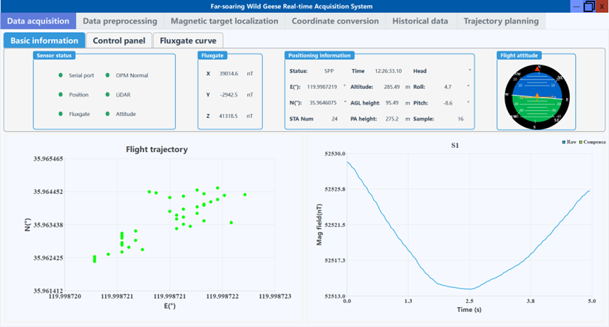
(1) The data collection section
includes real-time data parsing, reception, display, and storage. In this
section, several parameters can be configured, such as the display length of
magnetic field curves, real-time mean value removal, real-time magnetic anomaly
optimization filtering, magnetic data compensation and other algorithms, and
the sampling rate.
(2) The data
preprocessing section can process the saved data of this software, including
the adaptive filtering, low-pass filtering, high pass filtering and band-pass
filtering. Furthermore, it can perform data compensation processing for the
filtered data.
(3) Real-time magnetic
mapping section supports the magnetic mapping display of the selected area with
one click.
(4) The coordinate
transformation section can convert three expressions of latitude and longitude
from each other.
(5) The historical data
processing part can manage, preview, and replay the data saved by this
software.
(6) The trajectory
planning section can be used to generate trajectory planning files for DJI M400
drone.
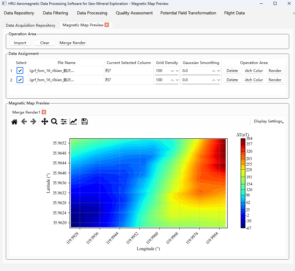
Hai Tian
Yi Se
aeromagnetic data processing software for geological & mineral exploration
(HRU) is an integrated data processing platform for the entire airborne
magnetic survey workflow. The system covers the complete business chain from
field data import, quality evaluation, data correction processing, to result
map output, Help technicians efficiently complete data processing and quality
control work for aeromagnetic exploration projects. The system is suitable for
aeromagnetic data processing needs in fields such as geological mineral survey,
oil and gas exploration, environmental geological survey, and engineering
geological investigation, Supports data formats of various aircraft types and
magnetometer systems.
Core Capabilities
|
capability
areas |
problems
solved |
|
data
acquisition management |
Unified
management of survey data, flight data, and flight log information to avoid
data scattering and version confusion |
|
quality
evaluation |
Quickly
evaluate the quality of collected data and promptly detect equipment
anomalies and collection problems |
|
data
correction processing |
Eliminate
interference factors such as diurnal variation, attitude, and gradient, and
restore the true geomagnetic field information |
|
flight
quality control |
Quantitatively
evaluate the flight line execution accuracy to ensure the collection
operation meets the design requirements |
|
result
output |
One-click
generation of standardized reports and maps to improve delivery efficiency |